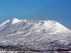
Maly Semyachik Volcano
|
||||||||||
| Location | ||||||||||
Volcano is located 20 km west from coast of the Kronotsky bay, 15 km northeast from Karymsky volcano, 140 km northeast from Petropavlovsk-Kamchatsky.
|
||||||||||
| Form and structure | ||||||||||
The structure of the volcano is 3 km long volcanic ridge build up with 3 close stratovolcanoes: Paleo-Semyachik, Meso-Semyachik, Ceno-Semyachic. Ceno-Semyachic include Troitsky crater with thermal Lake. |
||||||||||
| Composition | ||||||||||
| basalts, andesibasalts, andesites, dacites | ||||||||||
| Age | ||||||||||
| Paleo-Semyachik – 20,000 BP Meso-Semyachik – 11,000 BP Ceno-Semyachic – 8,100 BP |
||||||||||
| Links | ||||||||||
| Aviation color code |
GREEN |
| Last VONA/KVERT Releases |
| Hazard synopsis |
Hazard are therminal explosive eruptions which produce ash plumes, ash falls, pyroclastic and lahars. |
| Monitoring status |
satellite
|
| Eruptions |
|
1952/12
1945 – 1946
1852
1851/9 – 1852/7
1804 (?)
|

